[4 Techniques] Which Technology is used to predict Hurricanes?
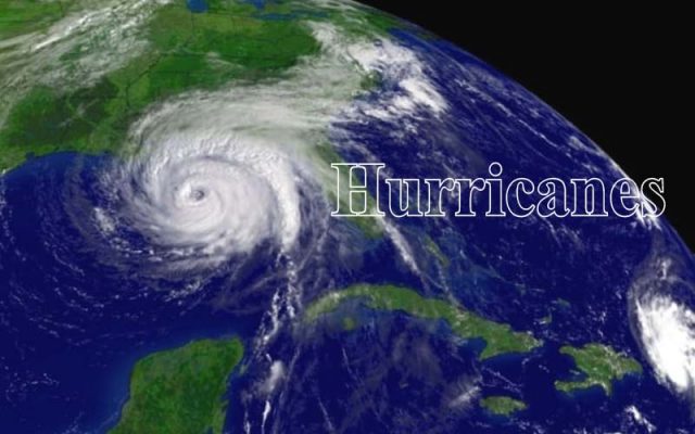
Hurricanes are big and moving storms. These are mostly produced with a wind speed of about 120 kilometers per hour or more than this. This speed is faster than a cheetah! The winds hurricanes cause can damage and sometimes destroy buildings and trees. Hurricanes are formed over warm ocean water, many times they also stroke land. When hurricanes reach land they push in all the water from the ocean with it. Causing floods and tsunamis to occur. Whenever a hurricane is formed, forecasters can predict the path it will take and how strong it can get from here. There are a lot of different types of hurricanes, the calling category of hurricanes is called the Saffir-Simpson hurricane scale.
A hurricane has different parts to it. First, there are the eyes, it is a hole in the center of the hurricane or storm. The wind speed in this area is much lower, there are fewer clouds and sometimes it is clear. Then there the eyewall, this is a ring of the thunderstorm. These storms swirl around the eye. The walls have the fastest wind speed and heaviest rainfall. And at last, there is the rain band. These can go far out from the hurricane’s eyewall. These bands are able to stretch for hundreds of meters. This is where thunderstorms and tornadoes are hiding.
A hurricane builds when there is a tropical disturbance in the atmosphere. This is the area over the ocean where storm clouds start to build. No one knows how and why these hurricanes are formed, but they do know warm water and winds are needed to form a hurricane.
There are a lot of different technologies used to predict hurricanes. In this blog, we have listed some of the most common ones for you to understand easily.
-
Dropsponders are used to predict hurricanes.
This is a reverse traveling weather balloon that helps in predicting hurricanes. These balloons are released by NASA, NOAA, Air Force Reserve centers, etc. These are sent via an aircraft into the hurricane and around it to learn more about what it has been caused by, what temperature it is off, what are the contents, what is its atmospheric pressure. These balloons also try to find the wind speed and the direction the hurricane is headed.
These balloons are dropped from the aircraft into sea surfaces to collect data from there as well. They collect the entire data from the top to the splashdown and then send the drop sondes to collect data from the ocean. Dropsponders are also able to collect the data around the hurricane. This information from drop spondees is sent to different weather channels which are then turned into forecasters and are developed into more accurate forecasts.
-
Global Hawk
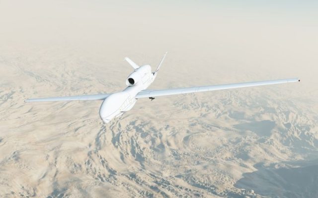
NASA sends a lot of hurricane monitors into the sky, water and ground. They also send the Global Hawk system to study these hurricanes. These systems are operable without the need of men, this is why they are safer than others. The craft that these are sent in can stat in the hurricane storm for more than a manned flight can. These can stay in the air for more than 20 hours and can travel as much as 9000 miles. This allows them to collect a lot of data at one time and is far better than other hurricane hunter flights. These flights are also able to drop more drop spondees and then these can be turned into manned flights. Since these are dropped from a higher altitude, they manage to collect more data.
-
Oceanic Gliders
Technology is crossing all limits. Scientists can now send robots under hurricanes to measure the right interaction of them with the ocean. In the past, only satellites and aircraft went into the sky, now robots too. These underwater robot gliders can take the exact measurement of the water temperatures and the theses can go as deep as 1000 feet, and help forecast the hurricane changes and their intensity. The data that is sent from these water robots is directly sent into the computer models, this is for near-real-time and to help get a better analysis of the oceanic conditions.
-
Microwave Imagery
Mant satellites can hide inside clouds at different layers of a storm with the use of microwave imagery technology. To easily understand this think about the x-rays for cats and dogs at the medical center. Scientists can see inside structures of the hurricane, this includes the eyes, rain bands, and eyewalls of it.
These inside details help forecasters get a better idea of how strong this hurricane was and when will it start to weaken or strengthen. These images can help us understand where the eye of the hurricane is forming and when will the storm start.